What was taken out of Bears Ears and Grand Staircase-Escalante National Monuments?
Many of the areas cut from protection in both monuments are rich in oil, gas, and coal resources
On December 4, 2017, President Donald Trump announced historic reductions to public lands in southern Utah, removing protections from hundreds of thousands of acres of iconic public lands in both Bears Ears and Grand Staircase-Escalante National Monuments. While the Interior Secretary has adamantly denied that resources like oil and gas were factors in the President’s decision, research of Interior, Bureau of Land Management (BLM), National Park Service (NPS), and Utah Department of Natural Resource (Utah DNR) records show that many areas cut from protection are rich in natural resources.
Bears Ears National Monument
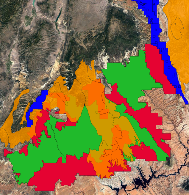
Donald Trump’s revised boundaries to Bears Ears National Monument will eliminate 1.1 million acres of protected land and replacing Bears Ears with two much-smaller monuments. The reduced monuments cut out vast swaths of sensitive desert landscapes and many iconic features. The sections of land cut from Bears Ears National Monument also include land rich in oil, gas, and uranium that is now open to possible future extraction.
Donald Trump is reducing the 1.35 million-acre Bears Ears National Monument to two smaller monuments; A 140,643 Shash Jaa National Monument surrounding the Bears Ears buttes and an 86,447-acre monument called Indian Creek National Monument in the Northeastern section of what was Bears Ears National Monument. [“Boundaries of new monuments still vague, details becoming clearer,” San Juan Record, 12/12/17]
The reduced monuments exclude previously-protected Cedar Mesa, a feature with “many archeological sites” that was included as a protected National Conservation Area in Rob Bishop’s PLI. Additionally, the re-drawn boundaries exclude Arch Canyon, Upper Comb Ridge, Valley of the Gods, and all wilderness study areas. [Jonathan Thompson, “How to make sense of Trump’s changes to Bears Ears,” High Country News, 12/05/17]
The revised boundaries also exclude Grand Gulch, a part of Cedar Mesa described as “the crown jewel of Bears Ears and the most famous archeological areas in the monument.” [“Trump erases 1.1 million acres of Bears Ears National Monument,” Friends of Cedar Mesa, 12/04/17]
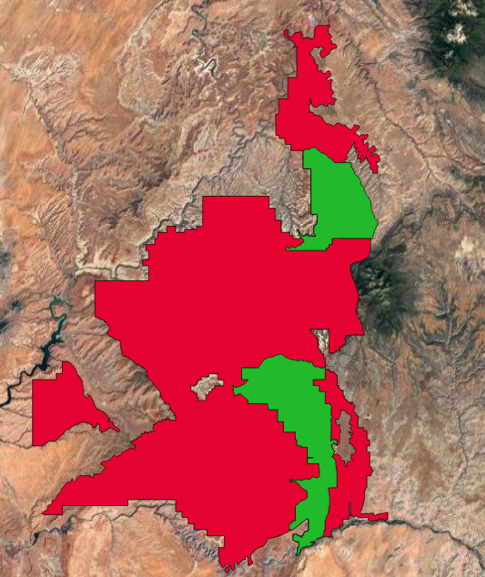
Red: Land cut from Bears Ears National Monument (Source: BLM) Green: Boundaries of new National Monuments (Source: BLM)
Much of the land cut from Bears Ears National Monument is rich in uranium which could be extracted now that monument protections have been removed. The cut areas overlap with eight uranium districts identified by the Utah Department of Natural Resources, as well as several permitted uranium mines. Some of the uranium districts removed from Bears Ears abut Canyonlands National Park and Natural Bridges National Monument.
Utah Governor Gary Herbert dismissed the possibility of oil and gas development in the Bears Ears area, but said, “‘the only thing that smacks of energy is the uranium… the uranium deposits are outside the monument now.'” [Juliet Eilperin, “Uranium firm urged Trump officials to shrink Bears Ears National Monument,” Washington Post, 12/08/17]
The Utah Department of Natural Resources says the Bears Ears area “has been productive for uranium deposits in the past, and some of the mining districts within the monument continue to hold some promise for future uranium production.” It identifies the uranium districts in Bears Ears in “decreasing order of importance” as “White Canyon, Elk Ridge, Deer Flat, Indian Creek, and Fry Canyon, which have moderate to low development potential.” [“Very little energy potential within Bears Ears National Monument,” Utah Department of Natural Resources, 12/04/17]
Data from BLM and the Utah DNR show that substantial portions of uranium districts have been carved from Bears Ears National monument, including on land that abuts Canyonlands National Park and Natural Bridges National Monument.
Red: land carved out of Bears Ears National Monument (Source: BLM) Yellow: Uranium Districts (Source: Utah DNR) Green: New Monument Boundaries (Source: BLM) Yellow dots: permitted uranium mines (Source: Utah DNR) Blue: Canyonlands National Park and Natural Bridges National Monument (Source: NPS)
Oil and Gas in Bears Ears
Ryan Zinke, Rob Bishop, and others have downplayed the possibility of oil and gas development in Bears Ears, even claiming that the threat of development is “‘a silly narrative'” because “‘there are no oil and gas resources'” in Bears Ears. The Utah Department of Natural Resources says no well has produced oil or gas in the Bears Ears region since 1992, and all the wells are now “‘plugged and abandoned.'” A University of Utah lands attorney doesn’t think development could happen in the Bears Ears region because it is too remote.
Ryan Zinke said, “‘I’ve heard this argument about Bears Ears’ oil and gas; that’s a nefarious argument… there are no oil and gas resources that anyone has reported in Bears Ears. It really is about multiple use and multiple use is grazing, timber management, recreation, being able to use in some places four-wheel drives.'” [Lee Davidson and Thomas Burr, ” Trump greeted by cheers and protests as he visits Utah, trims 2 million acres from Bears Ears and Grand Staircase-Escalante national monuments,” Salt Lake Tribune, 12/04/17]
Rob Bishop said of Bears Ears, “‘The idea that we’re going to give these over to oil and gas companies is a false narrative… It’s a silly narrative.'” [Dino Grandoni, “Legal Battle over national monuments is just beginning,” Washington Post, 12/6/17]
Governor Gary Herbert said it is a “myth” that oil and gas will come to Bears Ears. He said, “‘there is a lot of scaremongering’ about future oil derricks and natural gas wells” coming to the area. [Josh Dawsey and Juliet Eilperin, “Trump shrinks two huge national monuments in Utah, drawing praise and protests,” Washington Post, 12/04/17]
“There are dozens of abandoned oil and gas wells within monument boundaries, but none are active, according to Utah’s Division of Oil, Gas & Mining. The last producing well in the monument was drilled in 1984 and stopped producing in 1992.” [Leigh Paterson, “Oil & Gas eyes fringes of Bears Ears,” Inside Energy, 9/1/17]
The Utah Department of Natural Resources says that 287 oil and gas wells have been drilled within the Bears Ears National Monument, and all have been “plugged and abandoned.” Of those wells, “only nine produced oil and six produced gas. 302,027 barrels of oil have been produced with 77 percent of it coming from one well and 94 percent coming from just three wells. These locations were all near each other on the Bluff bench. A total of 204,747 mcf of gas has been produced.” [“Very little energy potential within Bears Ears National Monument,” Utah Department of Natural Resources, 12/04/17]
John Ruple, a public lands law professor at the University of Utah, said it is “‘unlikely that we would see significant exploration and development” of oil and gas “deep within the monument.'” Ruple said, “‘that area is just too inaccessible. The oil and gas potential is very low and the cost of getting any product out to a refinery and to market would be very high.'” [Leigh Paterson, “Could drilling rigs pop up in Bears Ears National Monument in Utah?,” NPR’s Marketplace, 12/04/17]
John Rogers, Associate Director of Oil and Gas at the Utah Division of Natural Resources says, “‘Historically, in say the 60’s, 70’s, and 80’s, there was some drilling out in this area, but nothing significant was found,” said John Rogers, Associate Director of Oil & Gas at the Utah Division of Natural Resources. “So all the wells out there have been plugged and abandoned…Now, on the fringe, up to the north, there are some people leasing. Within the monument, nothing… When oil was up above $100 per barrel, nobody was racing out here to do anything. Everything was in the northern part of Utah, the Uinta Basin… Now with oil down to $45, $50 per barrel, there’s even less incentive. If they shrink the size of the monument or alter it in some way, I don’t see anyone rushing in there because they’ve had decades to do it and they’ve done nothing.'” [Leigh Paterson, “Oil & Gas eyes fringes of Bears Ears,” Inside Energy, 9/1/17]
Others disagree—a Utah legislative commission tasked with public lands issues wrote a letter urging Zinke to shrink Bears Ears because the monument has “rich” oil and gas potential. Kathleen Sgamma of the Western Energy Alliance concurred —she said there “‘certainly is industry appetite for development” in Bears Ears, referring to an effort from oil and gas operators to nominate BLM land in the Bears Ears area for leasing. San Juan County Commissioner Phil Lyman says the Bears Ears region “has been blessed with tremendous productive capacity” and “those who say there are no minerals in the monument are misinformed.”
A letter to Ryan Zinke from the Commission for the Stewardship of Public Lands says Bears Ears National Monument “encompasses rich uranium mines, gold mines, and oil and gas.” They wanted the monument reduced or eliminated because they believed it threatened “existing oil and gas exploration and production activities.” [Utah Commission for the Stewardship of Public Lands, Letter to Ryan Zinke, 5/25/17]
Kathleen Sgamma of the Western Energy Alliance said of Bears Ears, said: “‘there certainly is industry appetite for development there (in Bears Ears), or else companies wouldn’t have leases in the area.” [Pamela King, “Changing Bears Ears designation is no western energy bonanza,” E&E, 4/03/17]
San Juan County Commissioner Phil Lyman, in a Facebook post, said, “those who say there are no minerals in the monument are misinformed. It is very true that extraction is unlikely, given the terrain, markets, federal ‘protections,’ and government regulations, but this region has been blessed with tremendous productive capacity.” [Phil Lyman status update, Facebook, accessed 12/15/17]
Parts of the land carved out of Bears Ears include the oil-rich Paradox Basin and its underlying Cane Creek shale, which the Utah Geological Survey is researching to “identify potential exploration areas” for oil and gas.
The northeast corner of Bears Ears National Monument overlaps with the Cane Creek shale layer of the Paradox Formation, and there are “a few wells in BENW and the western Paradox Basin” in SE Utah. [“Very little energy potential within Bears Ears National Monument,” Utah Department of Natural Resources, 12/04/17]
The Utah Geological Survey is currently researching the Cane Creek shale layer, which is part of the oil-rich Paradox Basin. The Utah Geological Survey says the goal of its research is to ” to identify potential exploration areas outside the current Cane Creek unit near Dead Horse Point State Park, as well as improve drilling and production techniques to reduce costs and environmental impacts.” Both the Paradox Basin and the Cane Creek shale are under land that the Trump administration wants to carve out of Bears Ears National Monument. ” [Craig D. Morgan, “Understanding Southeast Utah’s Cane Creek Oil, a Continuing Challenge,” Utah Geological Survey, 05/02/15]
The BLM said there is “high potential” and “moderate potential” for oil and gas development the Bears Ears region. Oil companies are aware of this, and are “interested in exploration.” Since 2013, producers have asked BLM to include 100,000 acres of land in or near Bears Ears in lease sales.
The Utah BLM’s 2008 Resource Management Plan identified “much of the area” in what would later become Bears Ears National Monument as open to oil and gas leasing. A spokesman for BLM, Lisa Bryant, said in June 2017 that if Bears Ears is reduced, BLM would “‘continue to carefully consider all nominated parcels.'” [Brian Maffly, “Oil and gas industry will pounce if Bears Ears shrinks,” Salt Lake Tribune, 6/19/17]
A map from BLM’s 2008 Resource Management Plan for the area identified swaths of land within what became Bears Ears National Monument as having “high potential” or “moderate potential” for oil and gas development.
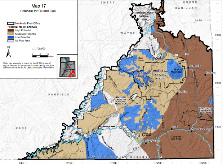
Source: BLM
“Since 2013, energy companies have unsuccessfully asked the BLM to lease more than 100,000 acres for oil and gas development within or near public lands that became the monument,” including “88 requested parcels, which are clustered along the eastern fringes of the monument, near Bluff on the south and Hatch Point on the north. The areas have long been subject to exploratory drilling.” [Brian Maffly, “Oil and gas industry will pounce if Bears Ears shrinks,” Salt Lake Tribune, 6/19/17]
Kirkwood Oil and Gas held leases within Bears Ears National Monument before it was designated in 2016. Its mineral rights were not impacted by the monument. [Brian Maffly, “Oil and gas industry will pounce if Bears Ears shrinks,” Salt Lake Tribune, 6/19/17]
The oil industry “is still interested in taking a look. Energy companies have sent requests to the U.S. Bureau of Land Management to include more than 100,000 acres of land within or near Bears Ears in upcoming lease sales. Those requests inform BLM how to design their oil and gas leasing. That doesn’t mean they will follow through on drilling, but it does mean they are at least somewhat interested in exploration.” [Nick Cunningham, “Don’t count on a Utah shale oil boom despite President Trump actions,” USA Today, 12/05/17]
BLM says there are 23 existing oil and gas leases within Bears Ears National Monument. They are listed below. The lessees include a variety of oil companies including Exxon Mobil, EOG Resources, Kirkwood Oil and Gas, Nerd Gas Co., EP Energy E&P Co, and Stone Energy Co. Other leases are held by individuals, and some leases have operating rights belonging to another company. Nearly all of these leases appear to have been carved out of Bears Ears National Monument.
Oil and gas producers are “working on the fringes” of Bears Ears National Monument, “to the east and the north of the current boundaries.” Utah’s BLM says there are “23 existing federal oil and gas leases, all at least partially or wholly located within the boundaries…'” There are no permits to drill on those leases at this time.” [Leigh Paterson, “Could drilling rigs pop up in Bears Ears National Monument in Utah?,” NPR’s Marketplace, 12/04/17]

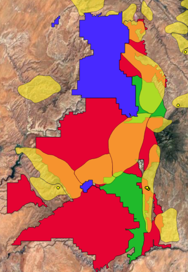
Red: Original Bears Ears National Monument boundary (Source: BLM) Green: National monument boundary after reductions (Source: BLM) Grey: BLM oil and gas leases: (Source: Utah Department of Natural Resources) Source: BLM, Utah’s SITLA
In addition to carving out the 23 oil and gas leases, the new Bears Ears National Monument boundaries carve out five oil and gas fields identified by the Utah Department of Natural Resources Oil Gas and Mining Division on the southeastern and northeastern edges of the monument.
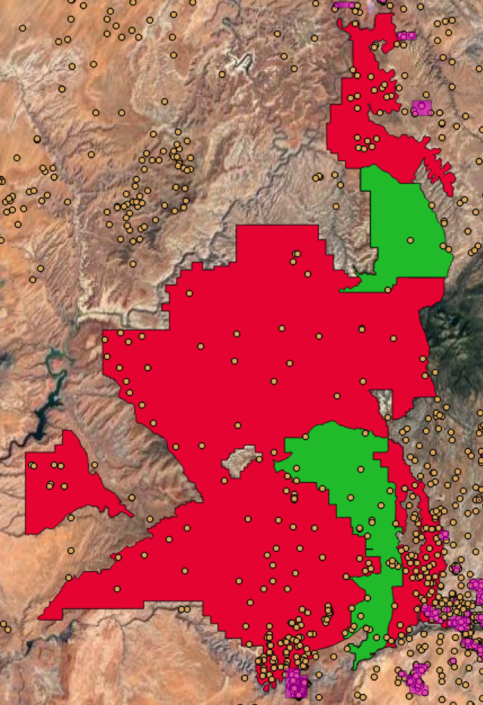
Red: land carved out of Bears Ears National Monument (Source: BLM) Green: New monument boundary (Source: BLM) Purple: Oil and gas fields (Source: Utah DNR) Orange dots: oil and gas wells (Source: Utah DNR)
The Utah Department of Natural Resources has identified the potential for the development of potash, salt, limestone, sand, and gravel within the boundaries of Bears Ears National Monument. [“Very little energy potential within Bears Ears National Monument,” Utah Department of Natural Resources, 12/04/17]
Grand Staircase-Escalante National Monument
Donald Trump’s revised boundaries to Grand Staircase-Escalante National Monument in Southeastern Utah reduces the monument by nearly half and creates three smaller monuments. The revision carves out a variety of natural resources including coal deposits, oil and gas fields, and other extractable resources.
Donald Trump issued an order changing Grand Staircase-Escalante National Monument, which was previously 1.9 million acres, into three smaller monuments; The Grand Staircase monument (209,993 acres), the Kaiparowits monument (551,034 acres), and the Escalante Canyon monument (242,836 acres). [David DeMille, Trump signs order reducing Utah national monuments to smaller pieces,” St. George Spectrum, 12/04/17]

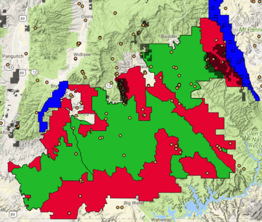
Red: Land cut from Grand Staircase-Escalante National Monument (Source: BLM)
Green: Boundaries of new National Monuments (Source: BLM)
Parts of Grand Staircase-Escalante National Monument that were carved out of the monument include the Kaiparowits Plateau, which includes Utah’s biggest coal field. Much of the area carved from Grand Staircase-Escalante National Monument includes coal deposits which are will become available for leasing, including on land bordering national parks.
“The U.S. Geological Survey estimated that 62 billion tons of coal lies in the Kaiparowits Plateau, an area that was within Grand Staircase-Escalante and that is important to paleontologists for its Mesozoic Era past. It is Utah’s biggest coal field, but there are no mining leases within it. In 1996, the year President Bill Clinton designated the monument, the federal government bought out the 18 existing leases.” [Laris Karklis, et al, “Areas cut out of Utah monuments are rich in oil, coal, uranium,” Washington Post, 12/07/17]
A substantial portion of land cut from Grand Staircase-Escalante National Monument includes coal deposits recognized by the Utah Department of Natural Resources. Additionally, all portions of Grand Staircase-Escalante National Park abutting Bryce Canyon and Capital Reef National Parks have been eliminated. Some of the portions of eliminated land abutting Bryce Canyon National Park include coal deposits.
Red: land carved out of Grand Staircase-Escalante National Monument (Source: BLM) Green: New monument boundary (Source: BLM) Pale Orange: Coal deposits on BLM land (Source: Utah DNR) Bold Orange: Coal deposits on land carved out of Grand Staircase-Escalante National Monument (Source: Utah DNR) Blue: Bryce Canyon and Capital Reef National Parks (Source: NPS)
Land cut from Grand Staircase-Escalante National Monument also has potential for oil and gas development. In addition to carving out many of the monument’s nearly 50 oil and gas leases, president Trump’s reduction also excludes an oil field and opens up land adjacent to Capital Reef and Bryce Canyon National Parks to drilling.
“The original Grand Staircase-Escalante area also contains limited oil and gas reserves and about 50 authorized oil and gas leases… Most lie outside the new borders.” [Laris Karklis, et al, “Areas cut out of Utah monuments are rich in oil, coal, uranium,” Washington Post, 12/07/17]
The redrawn monument boundaries exclude authorized oil and gas leases throughout Grand Staircase-Escalante National Monument and open up land adjacent to Capital Reef National Park to drilling.
Red: land carved out of Grand Staircase-Escalante National Monument (Source: BLM) Green: New monument boundary (Source: BLM) Grey: Oil and gas leases (Source: Utah SITLA) Orange dots: Historic oil and gas wells (Source: Utah DNR) Blue: Capital Reef and Bryce Canyon National Parks (Source: NPS)
One portion cut from Grand Staircase-Escalante National Monument includes an oil field identified by the Utah Department of Natural Resources. This portion has dozens of oil wells.
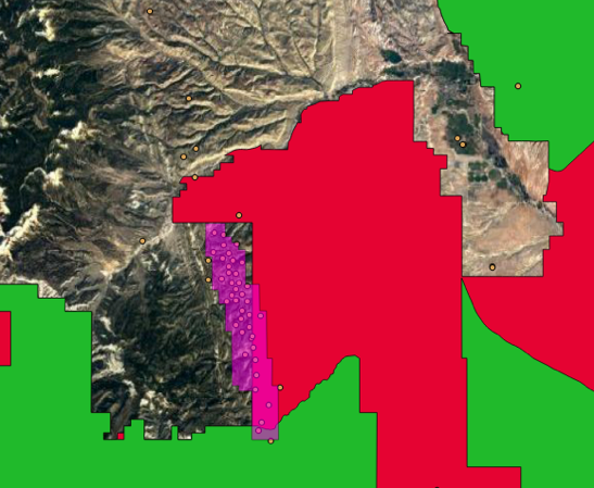
Red: land carved out of Grand Staircase-Escalante National Monument (Source: BLM) Green: New monument boundary (Source: BLM) Purple: Oil and gas fields (Source: Utah DNR) Orange dots: Historic oil and gas wells (Source: Utah DNR)
A number of sensitive and unique geological features have been carved out of Grand Staircase-Escalante National Monument, including land abutting national parks, slot canyons, and hoodoos.
Areas cut from Grand Staircase-Escalante National Monument include the Hole in the Rock Trail, Peekaboo Slot Canyon, land abutting Capitol Reef National Monument, land abutting Bryce Canyon National Park, Red Breaks, Zebra Slot Canyon trailhead, Spooky Slot Canyon, the Wahweap Hoodoos, and the Toadstool Hoodoos. [Source: BLM maps]
Also published on Medium.